 |
 |
Contour map of Twin Peaks (left); contour map of Tilted Crater Lake (right).
Slicing techniques appear in one of the most powerful ways we have for representing three-dimensional information on a two-dimensional page, namely the contour map. If we imagine an island completely covered by a flood, then we can generate a contour map by taking an aerial photograph at noon each day, as the water level subsides to reveal the mountaintops and valleys, depressions and mountain passes. For each water level, there is a shoreline, or a collection of different shorelines, all at the same height. We can think of such a shoreline as a horizontal slice of the original island. By keeping track of the way these shorelines change and come together, we arrive at a complete record of the topography of the island. Since each point on the island has exactly one height, no two of these contour lines will intersect. We can then draw all of the lines on the same diagram and number them to indicate the elevation of all of the points on a given contour.
|
|||
Contour map of Twin Peaks (left); contour map of Tilted Crater Lake (right). |
Such a contour map contains a great deal of information about the third dimension, height. An architect could reconstruct a model approximating the surface by cutting out a piece of thick cardboard for the region surrounded by each contour line and stacking the pieces one on top of the other. To get a more accurate model, we could take aerial photographs more frequently to obtain intermediate contour lines, or we could sand off the corners of the model to remove the "terracing." A construction engineer could then weigh the model and compare it to the weight of the cardboard representing a cubic foot of earth in order to estimate the total amount of dirt on the island.
We can gain useful information from the contour map even without constructing a model. To plan her ascent of one of the peaks, a mountain climber can find on the contour map the best way of approaching the base of the mountain across the foothills and can estimate the steepness of various paths to the top.
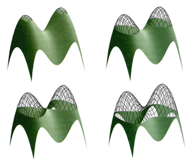
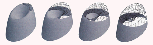
When we consider the slice history of an island, formed when the flood waters subside, we notice especially the "critical levels" where something interesting happens. A new shoreline suddenly appears as the water level drops below a mountain peak, or a lakefront disappears as the water drops below the bottom of a pit. (It is best to think of the island as made out of some porous material, so no water gets "trapped" as the level goes down.) Another interesting feature is a pass, where two contour lines come together to become one, or when one contour line comes around to meet itself and form two contours. These two cases are exemplified by the slice histories of two islands, which we may call "Twin Peaks" and "Crater Lake."
| ||
Slice history of Twin Peaks. |
For Twin Peaks, the first critical level consists of two points, which are the peaks of the two mountains. As the water level subsides, these points grow to small ovals. Then at a third critical level, the two ovals merge and form a single shoreline. The topology of the island is described by saying that it has two peaks, one pass, and no pits.
Crater Lake has a different sort of slice history. As the water subsides, the first thing we see is a circular rim, which splits into two pieces, a shoreline and a lakefront. The lake then dries up, leaving a single shoreline. If the topography is altered by a small earthquake, which displaces Crater Lake so that one part of its rim is higher than the rest, then we get a slightly different picture. As the water subsides, we see a single point, which grows to an oval. Then two arms reach out from the oval and come together at a pass, at the low point of the rim. Below this level, we have two contour lines, a shoreline and a lakefront. As before, the water continues to subside, and the lake dries up. The slice history of the tilted Crater Lake shows one peak, one pass, and one pit.
| ||
Slice history of tilted Crater Lake. |
It turns out that, for an island with a single shoreline, the number of peaks plus the number of pits is always one more than the number of passes. This result is called the critical point theorem, and it is the start of one of the most powerful of modern techniques in topology and geometry, with applications to physics and engineering. Generalized critical point theory is called Morse theory, after the American mathematician Marston Morse who extended it to higher dimensions.
We can begin to appreciate the power of critical point theory by placing ourselves once again in the viewing position of A Square, floating on the surface of the water. He himself is unaware that the water level is changing, and he will experience the slice history of Twin Peaks as a sequence of two-dimensional shapes changing in time. As he observes, two ovals appear and then come together to form a single figure. It would be difficult for him to come to a complete appreciation of the actual three-dimensional shape of the island, but at least he could distinguish this island from one having only a single peak. We in three-space do not have to rely only on the sequence of slices since we have the luxury of being able to create a three-dimensional model.
What would be the analogous experience for us, here on the "surface" of our three-dimensional water level? If there were some hyperisland covered with water, then as the flood waters in the fourth dimension began to subside, two ovaloids might appear and then come together to form a single object. By analogy we realize that we have just observed the slice history of Twin Hyperpeaks, with two high points extending into some fourth spatial direction that we cannot experience directly. This time we do not have the ability to construct the various contours out of cardboard and stack them up to make a model. We have no four-dimensional building materials and no fourth direction in which to stack them up. It is all the more remarkable then that modern computer graphics can exhibit the slice histories of complicated hypersurfaces in four-dimensional space, what the mathematicians call the contours of a three-variable function graph. At the end of Chapter 4, we will use this sort of contour map analysis to help us visualize data sets from geological sciences.
| Slicing Doughnuts and Bagels | ||
| Table of Contents | ||
| Slicing Cones |